

Over the next month, the NSTA will be carrying out user research on the recently restructured Data and Insights section of the website.
We want to understand if the change makes it easier for visitors to the website to find what they are looking for, whether that be analysis, downloads, or information. We’d appreciate your help to improve how accessible and discoverable NSTA data and tools are. To contribute, please share or fill in the following questionnaire by 22nd March. There is an opportunity register interest in providing a user interview to go into further detail at the end of the questionnaire
There are multiple ways to access the NSTA's data; through web mapping services, downloads, dynamic links, Power BI, Dashboards and via APIs. Some of these can be accessed within your own GIS software or directly in web maps and applications, removing the data management overhead. You should contact your software vendor if you are unsure on how to connect to services and APIs in your chosen software.

- Search for data on the open data site
- View and filter the data as required
- Download and other methods of using this data are available within the open data window
You can save a filtered version of the data tab as a dynamic web link on your desktop. This will enable you to always view the most up to date production data without applying the filters every time you visit the Open Data site. Copy the URL and save it as a shortcut on your desktop.
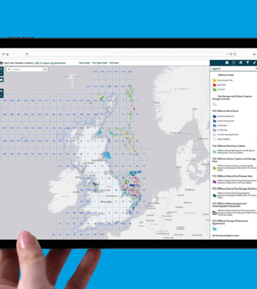
Once you have found the dataset you require, you can download from the webmap screen, there are four options provided:
- CSV
- KML
- Shapefile
- GeoJSON
Under download options there are two choices:
- Generate new download with latest data
- Download previously generated file, (usually time stamped)
The first option will initiate a fresh download which will go to your Downloads folder, this may take some time depending on the size/complexity of the dataset chosen.
The second will automatically begin a download of the last generated instance of the data, this can be quicker but may be slightly out of date.
Chose the relevant mapping application from the maps and dashboard home page: here
Spatial dashboards and Power BI reports can also be accessed from this page.
To use our data in your web maps, enter this URL into your web browser: https://data.nstauthority.co.uk/arcgis/rest/services. Find the service you need and add the chosen URL dataset, one at a time, to your web map.
The ArcGIS REST services are split into different folders by the coordinate reference system (ED50, WGS84, ETRS89 and BNG). They are separated again by content, for example: licences, wells and fields, see further down for individual folder access.
To learn more about the content in each service, read the summary information. This can be found via the Open data site. You must search for the data then select ‘view full details’.
This will bring up a page where you can find API Resources, under the ‘I want to…’ header. The data is provided in OGC WMS, GeoService or GeoJSON formats.
Further information can be found on the open data site FAQ's page here:
For help with accessing the NDR API's click here
Chose the relevant Power BI dashboard from the maps and dashboard home page: here
If you use the ESRI suite of software, and would like to connect to our services within your own GIS software, please follow the below work flow.
- Open ArcCatalog
- Go to GIS servers
- 'Add ArcGIS Server'
- Enter the following URL:
You can work with API data in Excel by importing the data by following the methods highlighted by Microsoft.
A guide has been put together to show petrel users how they can access the web services in Petrel Software. Please click here to view it.
Publicly available rest services
These are provided in the four most common coordinate reference systems (CRS) used within the NSTA and the oil and gas industry, as shown below:

NSTA virtual map gallery tour
Take a look at some of our most popular and newest maps; and get some hint and tips on how to use them.