


Operators Technology plans shows increasing focus on more effective and cost-efficient methods of Seismic Acquisition, integrating with the subsequent processing and interpretation steps.
Geophysical acquisition is being channelled to improve illumination of complex or challenging subsurface targets and reducing cost of acquisition. Processing by novel modelling and analytical techniques, enhancements to OBN methods and emerging technologies to improve reservoir mapping. Modeling approaches using AI and Machine learning, advanced analytical methods to improve knowledge of reservoir geology and previously hidden volumes helping to de-risk complex development targets.
Summary Findings (Click on Sub-Categories for detail)
- Geophysical Acquisition
Geophysical acquisition is being channelled to improve illumination of complex or challenging subsurface targets and reducing cost of acquisition. Technologies are focussed on more effective methods of seismic acquisition such as Autonomous Nodes, Nodes on a rope, Vertical Seismic Profiles and Passive Seismic giving better resolution and cost and smaller footprints. - Geology Processing & Imaging
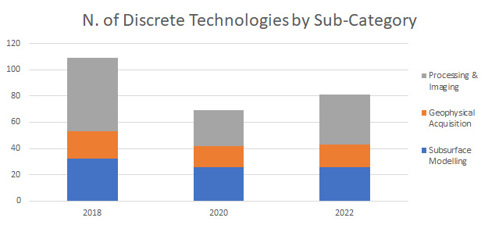
Processing and imaging technologies make up the bulk of operators focus in this category as operators are seek to take full advantage of technology advances enabling acquisition of rich, wide spectrum, multi component marine and ocean bottom data sets. Significant focus on reprocessing of legacy seismic data sets using advanced processing workflows to improve imaging quality is also reported. - Subsurface Modelling
Building on the advances in acquisition, processing and imaging, digital technologies make a strong contribution to subsurface modelling which accounts for a third of reported technologies. Integration of multiple data sets and artificial intelligence are contributing to improved workflow efficiency and managing model uncertainty. Using machine learning and advanced visualisation, operators hope to unlock further insights to complex subsurface geology and reduce exploration cycle-time.
Seismic & Exploration technologies
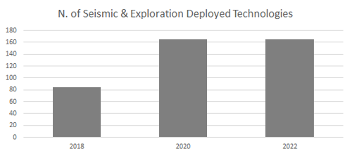
- Over 50 technology plans submitted each year from 2018 to 2022
- Showing an Increase in number of individual technologies reported, together with the number of operators reporting interest in this area in 2022.
- A number (35) of respondents not yet considering this theme (based on submissions)

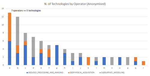
+ 35 operators not reporting Seismic & Exploration Techs
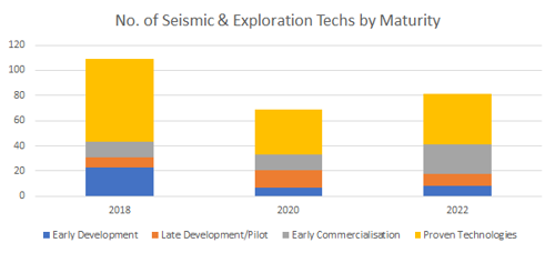
- Operators are focusing on a number of technologies ready for deployment (Early Commercialisation TRL 8) and Proven Technologies - Existing or in widespread use (TRL 9)
- The pipeline of technologies under development (TRL 1-7) remains healthy
Seismic & Exploration maturity and deployments

Once familiar with the technology the same operator deploys it at multiple assets (over 165 deployments reported/planned for 2021-23)

1. Geophysical Acquisition
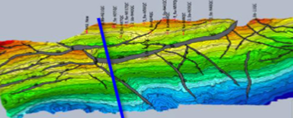
Focus is on continuously improving acquisition approaches (sampling density, frequency spectrum) resulting in enhanced imaging such as deeper imaging or fracture visualisation. Alongside this, advances in newer technologies such as DAS VSP continues along with ongoing efforts in cost reductions of acquiring time lapse 3D seismic surveys.
- Broadband Seismic Surveys applied in novel way to leverage wide source and streamer tow acquisition. New WAZ consolidated with existing survey, deliver rich azimuth MAZ for High Quality Subsurface Definition for accurate well positioning
- EnQuest (Bressay & Kraken)
- Ultra high density ocean bottom seismic - Densely sampled seismic data to improve reservoir imaging reduce volume uncertainty and inform depletion plan
- BP (Clair Ridge)
- OBN Acquisition and Processing - Ocean bottom nodes for improved seismic acquisition and processing
- Shell (Arran, Fram, Merganser & Shearwater) TotalEnergies (Alwyn) BP (Clair & Scheihallion)
- 4D Seismic Acquisition - Address the potential for imperfect reservoir sweep in a potentially complexly-connected reservoir. 4D acquisition and processing in thin injectite sand bodies subject to water sweep
- Harbour Energies (Brodgar, Catcher)
Technology Example :
Alwyn North OBN (TotalEnergies) - Improved Imaging (input to Inversion) with better velocity model & enhanced denoise (Higher Signal/Noise ratio) •Broader bandwidth due to OBN acquisition
View Technology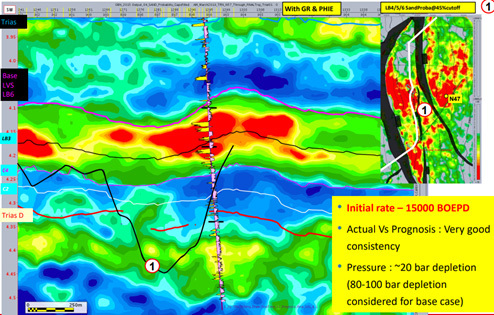
- DAS VSP - This is part of a field trial for utilising Borehole DFO for seismic surveillance on Clair Ridge, and is a first for BP North Sea. DAS VSP technology may help to augment the future 4D seismic programme through the provision of low cost, localised and on demand seismic surveillance.
- BP (Clair), also Total Energies (Culzean, Elgin) TRL 8 (Early Commercialisation)
- Marine Vibrator - Marine Vibrator Pilot - Technology reduces acoustic impact on marine life
- TotalEnergies (Elgin) TRL 8 (Early Commercialisation)
- Autonomous OBNs (deployment and retrieval), Nodes on a rope, Permanent nodes with AUV communication
2. Processing & Imaging
Processing & Imaging sub-category has seen an resurgence in numbers of technologies, Operators report focus on processing by novel modelling or analytical techniques, enhancements to OBN methods and emerging technologies that are improving reservoir mapping.
- 3D diffraction imaging/Diffraction Imaging - Seismic processing technique to better image sand injectites not observed by conventional processing. TAQA Diffraction Imaging for Fault and Sand Injectite Imaging at the Harding Fields.
- TotalEnergies (Maclure & Tullich) Taqa (Harding) TRL 9 Proven Technologies
- Extended Elastic Impedance Modelling Extended Elastic Impedance modelling. Use advanced analysis techniques to evaluate distribution of best pay within proximal turbidite fans and evaluate potential well opportunities.
- CNR (Thelma, Tiffany & Tony) TRL 9 Proven Technologies
- CNR (Thelma, Tiffany & Tony) TRL 9 Proven Technologies
- IKON JiFi inversion – Proprietary IKON JiFi inversion using Proprietary 2018 reprocessed 3D seismic data to better delineate the reservoir facies distribution across the Cook Field and improve Prospect evaluation in the Cook West / Chef Prospect area.
- Ithaca (Cook, Cook West) TRL 9 Proven Technologies
- Ithaca (Cook, Cook West) TRL 9 Proven Technologies
Technology Example :
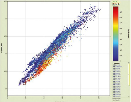
Joint Impedance and Facies Inversion technology Ikon’s “Ji-Fi” overcomes these pitfalls by recasting the seismic inverse problem as mixed discrete/continuous
View Technology
- Qeye inversion - Wide ranging seismic inversion project to improve the seismic characterisation of the Palaeocene and Upper Chalk interval. A direct probabilistic inversion using Bayesian principles to integrate statistical rock physics with a prior model driven by available well data to generate probability density functions describing the facies present across the entire data volume.
- Ithaca (Abigail) TRL 8 Early Commercialisation
- Paleoscan – External software trialled as a tool for improved reservoir imaging mapping
- Equinor (Rosebank) TRL 4-5 Late Development/Pilot
- Machine learning and waveform classification Using waveform classification combined with a machine learning approach to separating lithofacies in the Cambo Field
- Siccar Point (Cambo) TRL 1-4 Early Development
3. Subsurface Modelling
Subsurface Modelling continues to show increasing number of new technologies that are being adopted on greater number of assets, operators focus is on technologies using AI and Machine learning, and advanced analytical methods of improving knowledge of reservoir geology and previously hidden volumes.
- Baker Visitrak - Improved resolution and interpretation of existing and new data to improve modelling accuracy and reduce risk, geospatial reservoir navigation and analysis service.
- Harbour Energy ( Jade, Jasmine, Judy & Joanne) TRL 9 Proven Technologies
- Harbour Energy ( Jade, Jasmine, Judy & Joanne) TRL 9 Proven Technologies
Technology Example :
The VisiTrak™ geospatial reservoir navigation and analysis service lets you see more of your reservoir – a 360° view of the wellbore from up to 150 feet (45.7 m). You’ll know exactly where you are and where you need to go to build a better well.
View Technology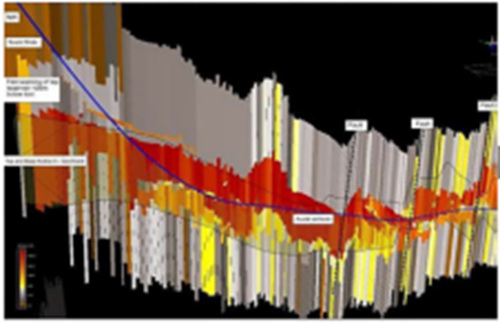
- COVIZ for 4D visualisation and integration - Integration and visualisation of 4D data. Tools for optimally visualising 4D or testing
- Harbour (Brittania, Lomond, Jade, Jasmine, Judy) TRL 9 Proven Technologies
- AI/Machine learning application of learnings from ongoing collaboration with ENRGeo using Cygnus as an example.
- Neptune (Cygnus) TRL 5-7 Late Development/Pilot
- Timelapse 4D seismic project with Heriot-Watt University (Edinburgh Time Lapse Project) - Developing tools and techniques for timelapse quatitative seismic interpretation / evaluation to monitor the water saturation and pressure changes in the reservoir and identify remaining oil areas. This is now actively used in CNOOC.
- CNOOC (Buzzard, Golden Eagle) TRL 5-7
Lifecycle Categories
Functional Categories