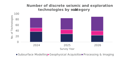
Seismic acquisition, processing and modelling solutions are included in operators’ technology budgets. Seismic is being used to update and extend development plans for mature fields by either reprocessing or reacquiring data over known areas to improve the imaging and provide a better understanding of reservoir compartmentalisation or depletion, for example.
Operators are using seismic acquisition for CS purposes, with a requirement for modern 3D seismic baselines prior to first injection.
Processing and imaging technologies are being used to elucidate intervals not previously a focus for oil and gas, e.g. in SNS modelling for CS, and software and workflows have been developed and updated to effectively model the behaviour of CO2 as a fluid in the reservoir.
New software and workflow developments include more advanced reprocessing of pre-existing mature data to gain further insight into missed and trapped volumes and the application of machine learning to more rapidly interpret historical data.
Seismic and exploration technologies
Operators are increasingly focusing on reprocessing to increase value from acquired data to drive time and cost efficiencies.
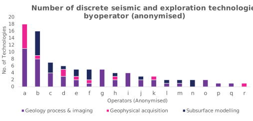
The interest in seismic and exploration technologies is concentrated within a subset of operators and is aligned with basin strategies and opportunities, which this year includes CS.
Seven operators carry at least five exploration technologies in their current plans, with 18 operators reporting at least one technology in this category.
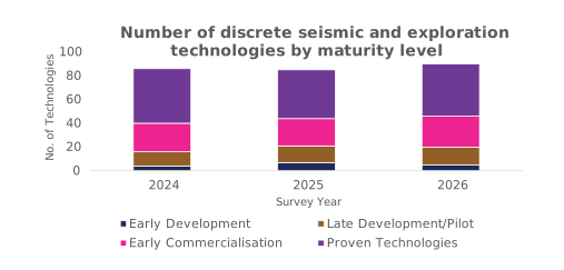
In common with other technology areas, operators are primarily focusing on deployable technologies in the early commercialisation or proven stages.
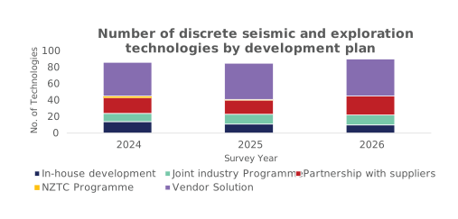
Operators are participating directly in the development of about half of the exploration technologies in their plans.
Readiness definitions: Early development (TRL 1-4), late development/pilot (TRL 5-7), early commercialisation (TRL 8), proven (TRL 9)
Operators’ focus remains on continuously improving acquisition approaches (sampling density, frequency spectrum) resulting in enhanced imaging, such as deeper imaging or fracture visualisation. Newly reported this year are towed streamer joint 4D full wave inversion (FWI), creating high resolution (25 Hz+) Vp models for each vintage for improved ‘gather flatness’ and imaging for input to LSM migration, as well as autonomous underwater vehicle (AUV) bathymetry surveys using repeat 4D geophysical acquisition from permanent nodes to monitor seabed subsidence. Emerging technologies include DAS, micro seismic events automatic detection, and processing algorithm development and tests.
- AUV bathymetry survey: AUV-based bathymetry surveys using repeat 4D geophysical acquisition from permanent nodes to monitor seabed subsidence over time.
- TRL 9 commercially available (New)
There is continued focus on extracting maximum value from existing data, with significant advances in reprocessing techniques in recent years. New this year are seismic depth imaging using a common reflection angle migration (CRAM) algorithm, a digital core analysis workflow, multi-sensor digitalisation of rock cores to create high-resolution continuous logs at centimetre scale, reverse time migration (RTM) re-imaging of field and surrounds, 3D PSDM re-imaging and FWI to re-image on the flank of a salt diapir. Emerging technologies includes machine learning for extracting micro seismic events from proprietary antenna recordings and surface DAS for 3D reservoir imaging.
- Common reflection angle migration (CRAM): Seismic depth imaging using CRAM algorithm to improve seismic image quality. This is a multi-pathing depth imaging algorithm that works natively in the subsurface incidence angle domain.
- TRL 9 commercially available (New)
- CoreDNA: CoreDNA is a digital core analysis workflow. Multi-sensor digitalisation of rock cores to create high resolution, continuous logs at centimetre scale. Captures geochemistry, sedimentology, rock mechanics and petrophysics in a single integrated dataset. Enables rapid lithofacies identification using AI algorithms before destructive sampling.
- TRL 9 commercially available (New)
- Reverse time migration (RTM) re-imaging of field and surrounds: The process of converting the high resolution FWI velocity model directly into a seismic image instead of performing conventional migration imaging, i.e. Kirchhoff migration. The key to this is providing a high frequency detailed velocity model (conventional velocity model building is limited to 7-8 Hz whereas FWI model building takes this to 40 or 50 Hz).
- TRL 9 commercially available (New)
- 3D PSDM re-imaging: 3D PSDM re-imaging FWI to re-image on the flank of a salt diapir.
- TRL 9 commercially available (New)
- Towed streamer joint 4D FWI: Create high resolution (25 Hz+) Vp models for each vintage for improved ‘gather flatness’ and imaging for input to a LSM migration. Create FWI imaging volumes including 4D FWI images to supplement 4D seismic volumes for interpretation. A maximum frequency of 25 Hz for 4D FWI was achieved to allow for FWI imaging.
- TRL 9 commercially available (New)
Technology example:
Optimised for large-scale surveys, the Petrel™ multiphysics plug-in provides tools to integrate electromagnetic (EM) and potential fields data with geological knowledge, seismic data, and well logs. Petrel Multiphysics comprises three individual modules: Petrel magnetotellurics (MT), Petrel controlled source EM (CSEM), and Petrel gravity and magnetics (GM).
Technology example link
Operators’ focus is on technologies using AI and machine learning, and advanced analytical methods of improving knowledge of reservoir geology and previously hidden volumes. New entries this year include is ultra high-density ocean bottom seismic – densely sampled seismic data to improve reservoir imaging.
- Ultra high-density ocean bottom seismic: Densely sampled seismic data to improve reservoir imaging, reduce volume uncertainty and inform depletion plan.
- TRL 9 commercially available (New)
Technology example:
CoViz 4D makes it possible for multi-disciplinary asset teams to simultaneously view and interrogate all available data from seismic to simulation, regardless of the original data source. CoViz 4D allows users to visualise and understand how development decisions affect the reservoir throughout the history of a field.
Technology example link